 |
| Our route up Commonwealth, over Kendall Catwalk towards Thomson and out Gold Creek. A better exit sketched out going up Silver Creek and out to Commonwealth directly... next time! |
Mt Thomson NE of Snoqualmie has been on the list ever since I saw pictures of it a few years ago. With a moderate 5.6 rating and amazing views into the depth of the Alpine Lakes Wilderness, it makes for an excellent climb.
Garrett and I hemmed and hawed for a while about the best approach for the climb, and finally landed on a single day push to move light and fast, unencumbered by overnight gear. We left the Commonwealth trailhead under wonderful weather at 5AM.
 |
| gearing up in the AM |
The going was very easy in the tracked out path up Commonwealth, and for the first time we did not cross at the log bridge, but kept going up the south / east side of the creek up towards the NE corner of the drainage. Luckily a skin track was going just where we needed it all day long, not too uncommon in this area, but we didn't think we'd be so lucky! It was especially nice to have a flat platform skintrack on the switchbacks up towards the col shared by the PCT as it snakes past Kendall.
 |
| gorgeous moon setting |
 |
| There are two snoqualmies. The moderate slopes facing the highway laced with lifts, and then there is the backside gnarliness. Snoqualmie seems to me a western town with a veneer of mellow slopes on the highway side and gnarly chutes just around the corner. |
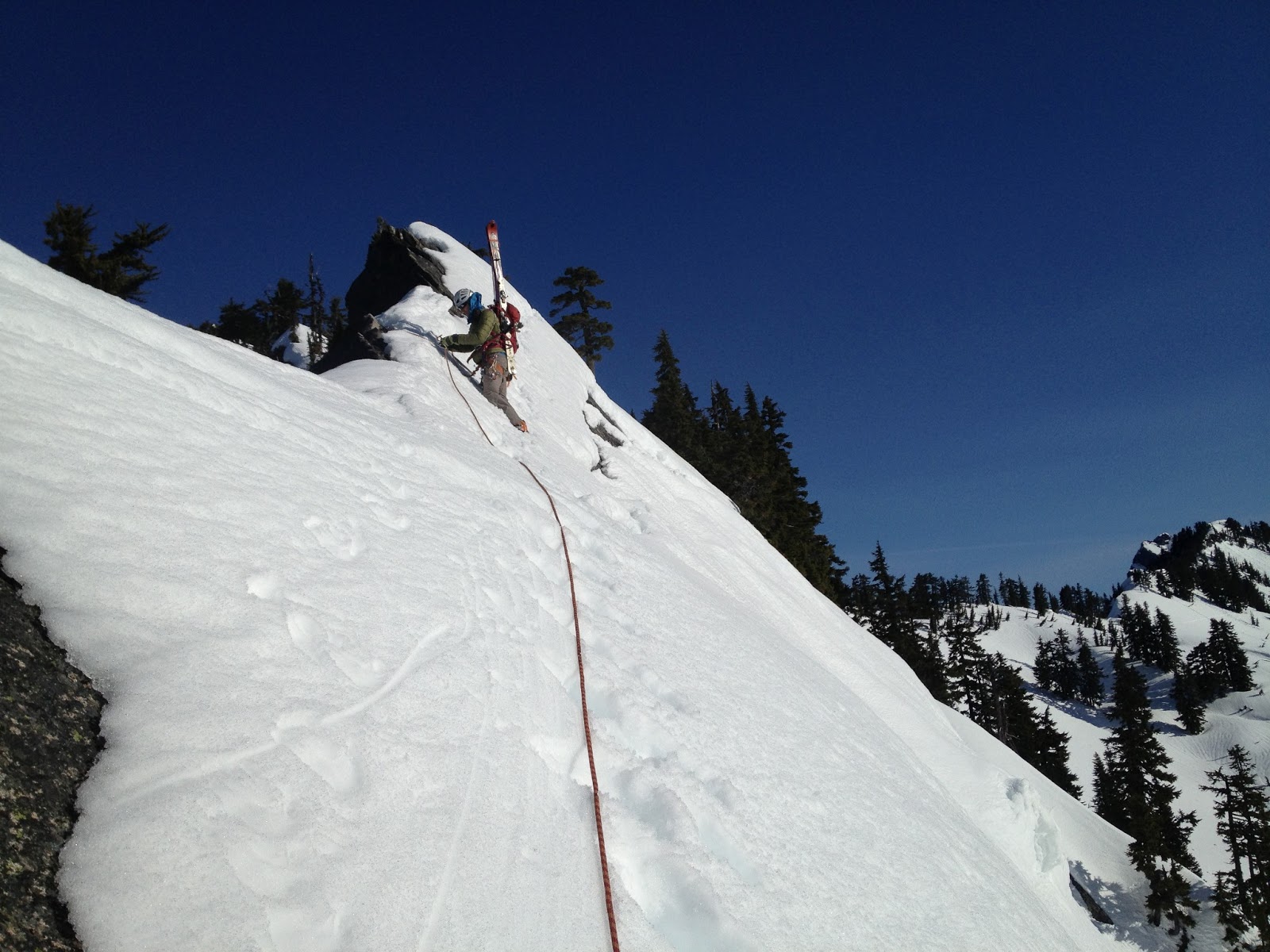
Once we topped out on the col - our timetable began to disintegrate. The next few hundred feet north along the ridge would not be easy going, and would have to be "quickly" pitched out. Drinking in the beautiful scenery as we set up an anchor was consolation for time flying by. I led across the snow traverse which was most sketchy at the beginning where only ~6" of slushy heavy snow clung to the slabs that perched above cliffs.
 |
| leading across the Kendall catwalk |
One solid cam placement kept me happy, but as I edged away from it and my crampons continuously scraped, I was wanting for some firm foot placements. After setting myself up for a fall long enough to go over the cliffs below, the firm snow finally materialized and I quickly bootpacked it up to a tree to sling and bring Garrett up. Following cautiously, he came up and came past to finish our traverse from the catwalk after an intense effort of ski / tree anchor yoga to get the rope from my left to right side over my pack with skis on it. Those K2 Shuksans are designed to grab ropes, I swear.
 |
| Looking past the catwalk at some gnarly terrain |
 |
| North Cascades or Snoqualmie Pass? |
From here on we continued to follow the skintrack that led us quickly down to Ridge Lake. We met up with the guys who had set the skintrack - they had come up the evening before and camped at the col by the catwalk. They too had their sights set on Thomson but after a long slide / fall down the face traversing Alaska, they had retreated to the saddle and were thinking options to get out. Not wanting to bail on the climb before we had suffered further, Garrett and I pushed up the alternate entrance to Bumblebee basin - the col NE of Gravel Lake.
 |
| Looking up the face after picking our way back down |
There was a good amount of small avalanche debris littering the face - likely from the late afternoon the day prior. As we traversed across and eventually booted up steep sections between small cliffbands, though, stability didn't seem like an issue. The southwest aspect of this face meant it would only really heat up in the late afternoon. At 12:30 once we had reached the top of the ridge we could see down into Bumblebee basin, and a bootpack route to the base of the climb. The hour was too late, however, and we decided to head back.
 |
| A tree near Ridge Lake provided much needed shade |
 |
| backside of Red Mountain with a giant cornice on top |
 |
Rainier and some of our route from Kendall catwalk
|
 |
| snow shapes |
Neither of us wanted to reverse the catwalk section after it had had more time to slush up and prepare itself for sliding. We had also both heard of horrible exits out Gold creek, but considering we hadn't ever gone up Silver creek before, Gold creek became the only reliable option.
 |
| Once again we found a skintrack to take us up out of Ridge Lake - thanks to the folks ahead of us! |
 |
| Garrett topping out with some great scenery behind |
We dropped back down to Ridge lake, cut across the ridge above Alaska Lake and skiied down for a few thousand feet in mellow treed east facing slopes that held decently good snow....bonus! In our excitement upon finding carvable conditions, we skiied a bit too directly down and found our selves in some more committing terrain than we had hoped for. After carefully picking our way through cliffbands and wet slide runouts, we finally crossed Silver creek and came to a stop near Gold Creek.... all we have to do now is follow the creek out, right?
 |
| Skiing wasn't bad! |
 |
| Last turns. Looking up towards Silver creek basin... we continued down and out Gold Creek... |
For miles and miles we followed the creek... crossing and recrossing when the conditions appeared better on the opposite side. Comical attempts to "read" the skintrack language of... "did they turn back and go that way" or "did they continue this way?" usually just wasted time. The best option seemed to be follow a track blindly until it turned around on you... then swear and follow it back to the junction and choose again.
 |
| ...crossing the creek... |
 |
| Hmmm which way? |
 |
| ...crossing the creek again... |
 |
| Tree and Silver Peak. I was thankful to start seeing familiar terrain as the sun went down... |
We eventually felt the valley starting to widen and cabins began appearing. Night had now mostly fallen as we skiied around a large lake, and then had to traverse right back over to the east side of the valley in order to catch the main road out. Hearing the loud rumble of tractor trailers was never so sweet, as we finally donned approach shoes and walked the road beside the buzzing traffic. We needed to get a further 2 exits down the highway, and that wasn't happening on foot this night. Luckily the WSDOT came through in the clutch and obliged the desperate request for a ride over to Summit West.
 |
| Booting time! |
 |
| Just a stroll along I-90 left |
 |
| Night photography while walking with a point and shoot. |
 |
| Thankfully we eventually got a ride from Hyak to West |
Many lessons were learned on this trip. Going in or out of Gold Creek will be avoided at all costs. During this time of year with rapidly changing snowpack, it may be unwise to try and day-trip a climb that features a prominent south slope bootpack to access the base. A camp in Bumblebee basin with an alpine start on the rock and an exit early enough to avoid south slope shenanigans seems to be the way to go. Or just waiting for summer.


No comments:
Post a Comment